La grotte des contrebandiers
The archaeological site of Smugglers’ Cave (la grotte des contrebandiers)
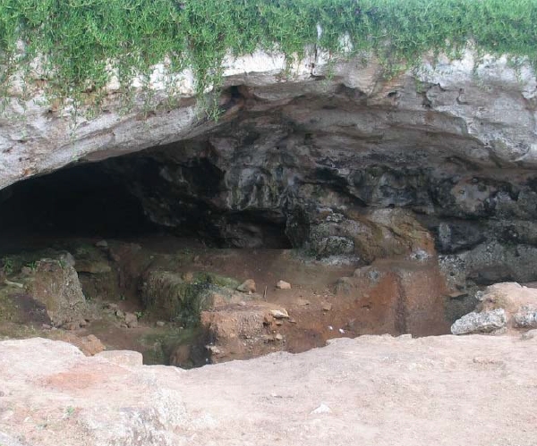
view from inside the caveis an important prehistoric site with remains
of early modern Homo sapiens. The site, located near the beach in Témara,
Morocco, was first discovered in the 1950s by Abbé Roche. Since
that time the site has yielded stone tools, animal remains, evidence
of the use of fire, and bones of the humans occupying the cave. In 2007,
new excavations at the site led by the University of Pennsylvania Museum
(UPM) and the Institut Nationale des Sciences de l’Archéologie
et du Patrimoine (INSAP) started. This blog will discuss work at the
site and how archaeologists go about setting up and doing the excavations.
Specialists participating in the research will be asked to contribute
blogs on their respective areas of expertise and how it relates to the
research at the site.
Work at the site to date demonstrates the potential of Smugglers’ Cave for understanding the occupation of the area by groups representing early anatomically modern Homo sapiens. Among the most important goals are to establish an absolute chronology of the Aterian occupations, to reconstruct thesmugglers\' cave in 2007 paleoenvironment in the area of the site and its use by the prehistoric inhabitants, to reconstruct the use of the site itself, and to verify the integrity of the deposits. To accomplish these goals, an international team of scholars representing many diverse specialties has been brought together, and they will rely on the very latest methods and theory in stone tool analysis, paleontology, geology, and absolute dating techniques.
The site of Smugglers’ Cave (grotte des Contrebandiers) is located
on the Atlantic coast of Morocco, along the coastal highway connecting
Rabat and Casablanca. The cave site is 270 meters from the ocean and
14 meter above the current high tide. The cave is formed in the ancient
coastline sandstone and its formation by wave action probably dates back
to about 125,000 years ago. After the sea retreated it gradually was
filled with sediment and in those sediments remains of at least four
archaeological cultures were found. These are the Mousterian in the lower
layers, the Aterian, the Iberomaurusian, and finally the Neolithic in
the topmost layers. The cave was discovered in 1955 by Abbé Jean
Roche who organized the first excavations in the 1950s. Since that time
four different teams have excavated at the site including the our excavations
which started in 2007.
The site is best-known for the important human remains it yields from the Aterian. This particular archaeological culture is interesting because it dates to the time period (between 60 to 100,000 years ago) when modern humans lived exclusively in Africa. In other words, better understanding these early humans might provide insights into human adaptations that ultimately led to the dispersal of humans throughout the globe. The second reason this period is of particular interest is because it is during this same period that archaeologists think modern human behavior develops.
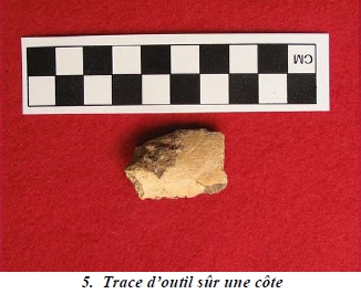
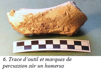
In addition to the human remains found at the site, the site has also yielded stone tools from all four archaeological cultures at the site, bones of the animals that probably served as food for the different human groups living at the site, shellfish (again a source of food), and ceramics from the Neolithic (the youngest of the set of occupations at the site). Other archaeological traces include the use of fire during the Aterian, and the digging of pits during Iberomaurusian and Neolithic times.
Even though we can guess the ages of the various cultures found at the site through comparisons with other sites were similar material was found, there are no reliable direct dates from the site itself. Earlier some carbon 14 dates were obtained, but the results are inconsistent and therefore new dates are needed. Re-dating the site is one of the major research goals of the current excavations. Other goals include the reconstruction of the environment at the time of the various occupations at the site, the reconstruction of the diet of the peoples living in the cave, the role of stone tools in these ancient cultures, and the integration of our collections with those from previous excavations at the site.
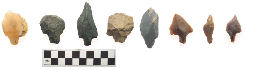
Exemples de pièces pédonculées
 |
 |
 |
|
 |
|
La grotte d’El Harhoura 2
Située sur la commune d’El Harhoura, la grotte d’El Harhoura 2 a été découverte en 1977 par André Debénath, année durant laquelle un premier sondage a été effectué (A. Debénath et F. Z. Sbihi-Alaoui). Des fouilles programmées se sont ensuite déroulées en 1996 (Debénath A. et El Hajraoui). Depuis 2001 et jusqu’à aujourd’hui, des campagnes de fouilles annuelles ont été menées dans le cadre la mission archéologique El Harhoura-Témara (Nespoulet et El Hajraoui).
Telle qu’elle est connue actuellement, la stratigraphie d’El Harhoura 2 présente une épaisseur de dépôts de plus de 7,5 m dans la partie avant de la cavité. La base de la stratigraphie n’a pas encore été atteinte. Six niveaux attribués au Paléolithique moyen sont surmontés par 1 niveau du Paléolithique supérieur et 1 niveau néolithique ancien (Cardial). Une deuxième salle profonde découverte en 2006, riche en vestiges archéologiques du Paléolithique supérieur, a été explorée en 2007. Elle est située à 15 m du porche actuel, confirmant les grandes dimensions de la cavité (plus de 20 m de longueur, 10 m de largeur), comparable à celle de Dar es Soltane 1.
Sept sépultures en position primaire ont été découvertes à El Harhoura 2 : 6 sépultures néolithiques et 1 sépulture très probablement attribuable au Paléolithique supérieur (étude en cours).
Plusieurs structures d’origine anthropiques sont également connues : fosses néolithiques (stockage de denrées alimentaires ?), structures de combustion et empierrements paléolithiques.
Une faune relativement abondante et diversifiée (plus de 27 taxons différents), une microfaune très riche et des industries lithiques (études en cours) ont permis de préciser le cadre paléoclimatique et les types d’occupations sur une longue période. Plusieurs fluctuations climatiques ont été enregistrées, allant d’un environnement relativement humide avec un paysage semi-ouvert à un environnement plus aride que l’actuel, avec un paysage ouvert de type savane. Les industries lithiques du Paléolithique moyen, bien que ne présentant pas de pièces pédonculées, rentrent parfaitement dans la variabilité de l’atérien du littoral atlantique. Les datations isotopiques (ESR, thermoluminescence, OSL, radiocarbone) sont en cours.
Premier gisement paléolithique ayant bénéficié d’une fouille assistée par ordinateur au Maroc, la grotte d’El Harhoura 2, comme celle d’El Mnasra, a également servi de chantier école en accueillant de nombreux étudiants marocains et étrangers.
http://www.persee.fr/web/revues/home/prescript/article/bmsap_0037-8984_1976_num_3_2_1846
Bull, et Mém. de la Soc. d'Anthrop. de Paris, t. 3, série XIII, 1976, pp. 165-173
CHRONOSTRATIGRAPHIE DES RESTES ATÉRIENS
DE LA GROTTE DES CONTREBANDIERS A TËMARA
(PROVINCE DE RABAT)
par Jean Roche
La grotte des Contrebandiers est située au km 17 de la route côtière Rabat-Casablanca, à 250 m au Sud-Est de l'anse des Contrebandiers, crique abritée qui assurait un approvisionnement facile à des groupes de pêcheurs et de collecteurs de coquillages ainsi qu'un abri sûr pour la navigation côtière.
La grotte est creusée dans une falaise en grès dunaire
dont le sommet atteint actuellement 14,10 m au-dessus du niveau de la
mer. Selon M. G. Beaudet, cette falaise est une formation « polycyclique » car
au cours de la transgression ouljienne, entre 95.000 et 75.000 ans B.P.,
la mer a atteint la falaise harounienne qui se serait formée entre
145.000 et 125.000 ans, détruisant toutes les formations intermédiaires
(1). Le creusement de la grotte se serait effectué durant l'Ouljien,
donc entre la quatrième pulsation transgressive (Harounien) et
la sixième (Mellahien).
Initialement, la grotte se présentait comme une cavité en
forme d'arc de cercle, longue de 30 m, dont l'ouverture large de 28 m était
orientée au Nord- Ouest. Toute la partie Nord-Ouest de la voûte
s'est brusquement effondrée après le Néolithique
(probablement au cours d'une secousse sismique) et actuellement il ne
subsiste plus de la cavité primitive qu'un large diverticule latéral
profond de 20 m et dont la largeur moyenne est de 11 m.
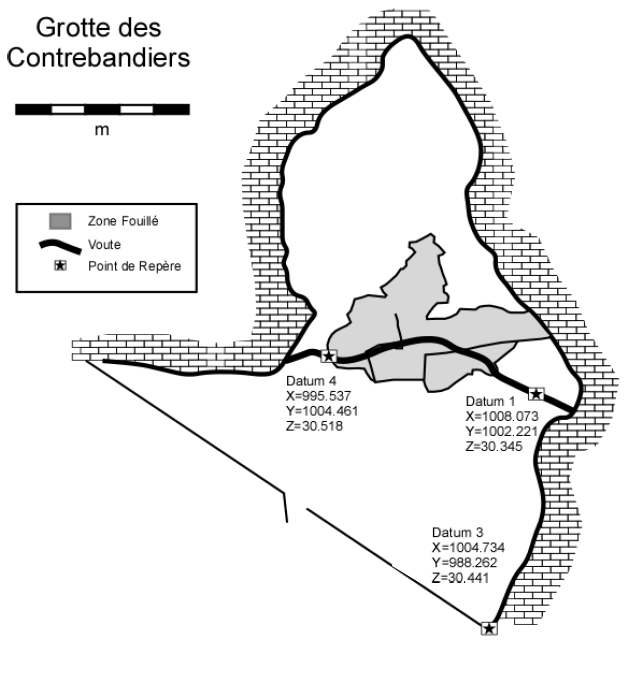
J'ai découvert ce gisement en 1955 et de 1955 à 1957 j'y
ai pratiqué un sondage profond en forme de L, à l'entrée
du diverticule, légèrement en retrait de l'extrémité actuelle
du plafond afin d'éviter les très gros blocs d'effondrement
de la voûte situés plus en avant. Longueurs : 4 m (N.E.-S.O.)
et 2 m (N.O.-S.E.) ; largeur : 2 m. Ce sondage permit d'établir
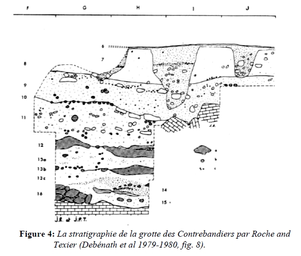
une première analyse stratigraphique du remplissage (2). Soit,
de haut en bas :
I. — Terres noires pulvérulentes, encombrées de blocs
d'éboulis. Dans leur partie supérieure et moyenne, elles
ont été bouleversées soit par des causes naturelles
(chutes de blocs), soit du fait des animaux fouisseurs, soit par l'Homme
(sépultures relativement récentes). On y trouve donc des
débris d'âges très divers...
(1)(2) Voir
onglet Sources-Auteurs